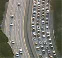
Non-tradional aerial mapping can put real-time traffic, fires, weather and emergencies into a geographic context. Utilizing platforms of opportunity and uncalibrated sensors demands a robust approach to automate the mosaicing and georeferencing of this imagery.
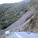
GPS referenced Caltrans survey data and onsite multi-view photographs are being prepared for merging into a georeferenced 3D model. Highway 140, the main road into Yosemite National Park, was closed in early 2006 by massive rock slide. For now, a temporary one-lane bypass has been constructed around the slide by Caltrans until a permanent solution is in place.
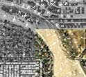
Accurately overlaying your own data onto online map resources can be difficult. The quality registration of geodata layers is also a prerequisite for data fusion, stereo extraction and visualization.
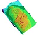
In 2005, new high resolution bathymetry and sidescan imagery was collected at Cordell Bank by California State University Monterey's Seafloor Mapping Lab for NOAA's Cordell Bank National Marine Sanctuary. This effort updated the best previously existing bathymetry acquired in 1985 by NOAA and processed by Kruse Imaging.